
- Other Counties
- ▸ Alabama
- ▸ Alaska
- ▸ Arizona
- ▸ Arkansas
- ▸ California
- ▸ Colorado
- ▸ Connecticut
- ▸ Delaware
- ▸ Florida
- ▸ Georgia
- ▸ Hawaii
- ▸ Idaho
- ▸ Illinois
- ▸ Indiana
- ▸ Iowa
- ▸ Kansas
- ▸ Kentucky
- ▸ Louisiana
- ▸ Maine
- ▸ Maryland
- ▸ Massachusetts
- ▸ Michigan
- ▸ Minnesota
- ▸ Mississippi
- ▸ Missouri
- ▸ Montana
- ▸ Nebraska
- ▸ Nevada
- ▸ New Hampshire
- ▸ New Jersey
- ▸ New Mexico
- ▸ New York
- ▸ North Carolina
- ▸ North Dakota
- ▸ Ohio
- ▸ Oklahoma
- ▸ Oregon
- ▸ Pennsylvania
- ▸ Rhode Island
- ▸ South Carolina
- ▸ South Dakota
- ▸ Tennessee
- ▸ Texas
- ▸ Utah
- ▸ Vermont
- ▸ Virginia
- ▸ Washington
- ▸ West Virginia
- ▸ Wisconsin
- ▸ Wyoming
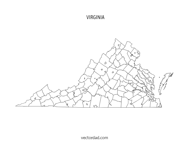
Virginia County Map: Editable & Printable State County Maps
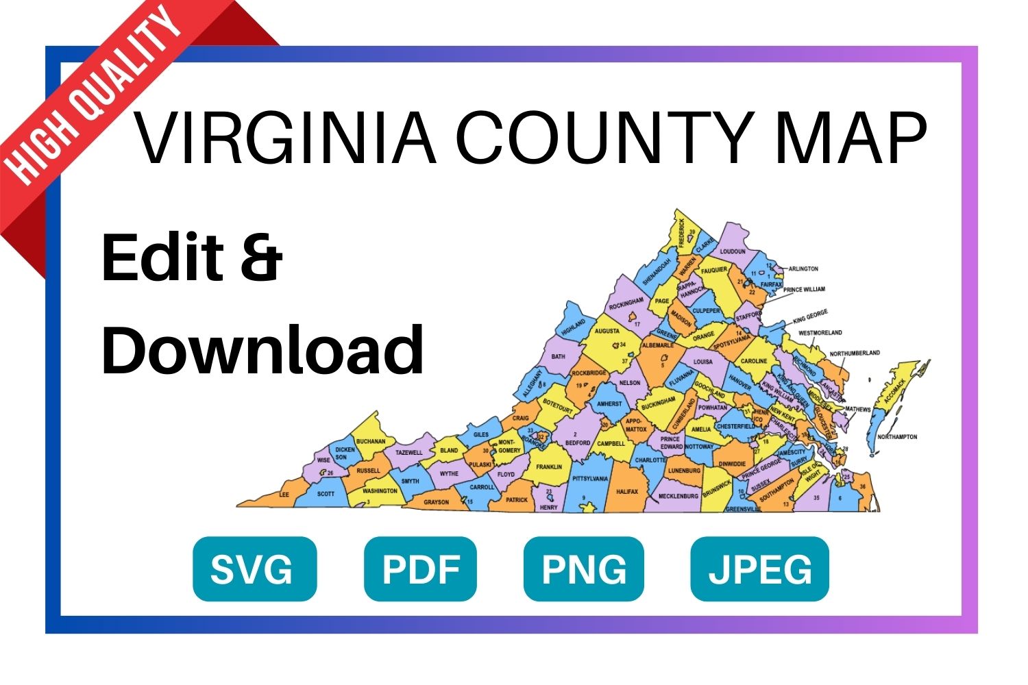
Download a free, editable Virginia county map in SVG, PDF, PNG or JPG. Perfect for classroom projects, presentations, geography research, and Cricut or Silhouette cutting machines.
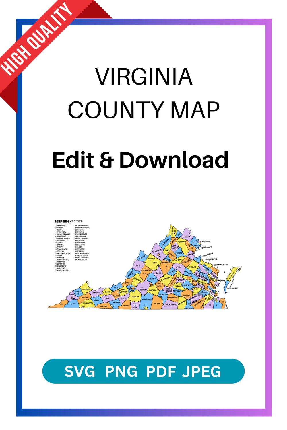
Types of Virginia County Maps
Choose from four styles of the Virginia county map — each available as a free editable download in SVG, PDF, PNG and JPG.
Virginia County Map — File Details
| Detail | Information |
|---|---|
| State | Virginia |
| Number of counties | 95 counties |
| Map type | Multi-colored county map (each county a distinct color) |
| File formats | SVG, PDF, PNG, JPG |
| Paper sizes | A4 and US Letter |
| Editable | Yes — customize text, colors, and elements in the online editor |
| Print ready | Yes — high resolution, suitable for home and professional printing |
| Cost | Free to download |
Download the SVG format — it cuts perfectly on all major cutting machines. Cricut Design Space and Silhouette Studio both import SVG files directly with no tracing needed.
Shop Cricut → Shop Silhouette →
What Can You Use This Virginia County Map For?
This free printable Virginia county map is used across a wide range of projects. Here are the most common uses:
| Use Case | Description |
|---|---|
| Education & classrooms | Teachers use county maps for geography lessons, quiz worksheets, and student reference handouts. |
| Research & data visualization | Researchers, analysts, and journalists overlay demographic, election, or economic data county by county. |
| Cricut & Silhouette projects | Crafters cut the SVG file to create vinyl maps, wood engravings, and personalised gifts. |
| Presentations & reports | Business and government presentations use county maps to illustrate regional coverage or service areas. |
| Travel & road trips | Travellers print county maps to plan routes and track visited counties in the state. |
| Real estate & planning | Agents and planners reference county boundaries when discussing territory, zoning, or coverage areas. |
| Wall art & home decor | Printed on A3 or larger, the colored county map makes a striking piece of wall art for Virginia natives. |
The FREE editable and printable Virginia county map with seat cities. These printable maps are hard to find on Google. They come with all county labels (without county seats), are simple, and are easy to print. This Virginia county map is an essential resource for anyone seeking to explore and gather more information about the counties of the state.
Detailed, Editable & Printable Maps of Virginia Counties
Looking for accurate maps of Virginia? Our Virginia County Map collection provides high-quality, customizable, and printable maps covering all 95 counties and 38 independent cities in the state. These maps are perfect for classrooms, research, planning, or business presentations.
Why Choose Our Virginia County Maps?
✅ Editable Formats – Available in PowerPoint, Illustrator, PDF, and image files.
✅ High-Resolution & Printable – Great for reports, wall charts, and educational use.
✅ Detailed County Boundaries – Clear outlines of counties and independent cities.
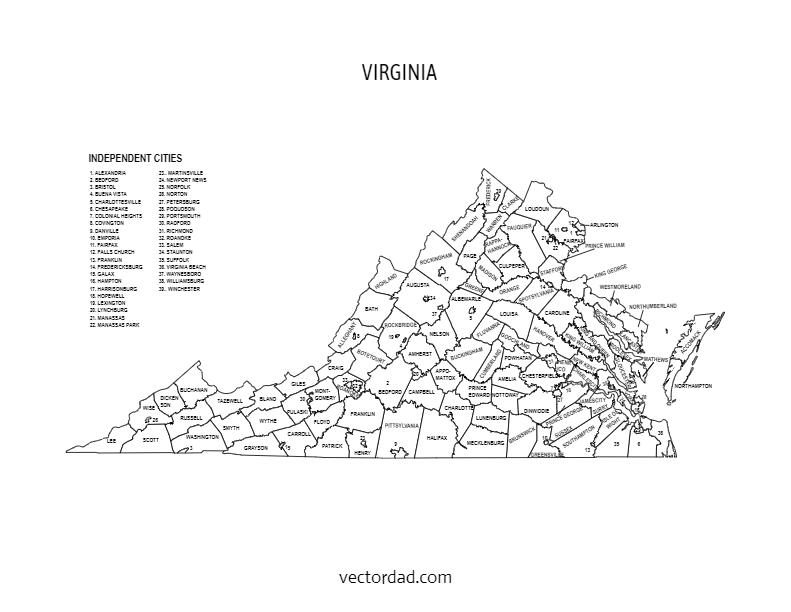
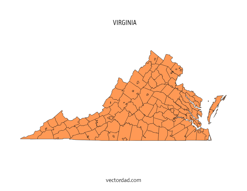
✅ Multiple Versions – Choose from labeled, blank (outline), and colored maps.
✅ Instant Download – Access your maps right away.
Who Can Use These Maps?
- Teachers & Students – Ideal for geography lessons, quizzes, and school projects.
- Businesses & Marketers – Highlight sales regions, service areas, or market data.
- Researchers & Analysts – Visualize demographics, politics, or economic studies.
- Government & Planners – Use for planning, zoning, and official reports.
- DIY Creators & Hobbyists – Customize maps for posters, crafts, or presentations.
What’s Included?
- Labeled Virginia County Map – Counties and independent cities clearly marked.
- Blank/Outline Map – Perfect for coloring, quizzes, or custom labeling.
- Editable Map Files – Modify colors, add text, or highlight regions.
- Printable PDFs & Images – Ready for high-quality printing and classroom use.
How to Use
- Select Your Map Style – Labeled, blank, or colored version.
- Download Instantly – Get PDF, PNG, or editable files.
- Edit (Optional) – Customize in PowerPoint, Illustrator, or Photoshop.
- Print & Share – Use for teaching, reports, or creative projects.
Get Your Virginia County Map Today
Our Virginia County Maps are accurate, easy to use, and perfect for education, business, or personal projects. Whether you need a blank outline for learning or a detailed labeled version for research, we’ve got you covered.
SUGGEST US
We are constantly working on the enhancment by adding various new templates. If you experience any issues or you have any suggestions for us with this editor tool, feel free to contact us at vectordad24@gmail.com.
The templates includes Virginia multi colored county map, Virginia county map outline with labels, Virginia colored blank county map, and Virginia county outline map with border. Please share with us any templates that you would like us to add to the gallery.
Virginia county map, whether editable or printable, are valuable tools for understanding the geography and distribution of counties within the state. Printable maps with county names are popular among educators, researchers, travelers, and individuals who need a physical map for reference or display. They can be used in classrooms for teaching geography, in offices for planning and analysis, or as wall maps for decoration.With their customizable and printable features, The maps of Virginia counties provide flexibility and convenience for users to use maps with county area boundaries that meet their specific needs. Whether used for educational, professional, or personal purposes.
List of 95 Virginia counties with seat cities
- Accomack County – Accomac
- Albemarle County – Charlottesville
- Alleghany County – Covington
- Amelia County – Amelia Courthouse
- Amherst County – Amherst
- Appomattox County – Appomattox
- Arlington County – Arlington (independent city)
- Augusta County – Staunton
- Bath County – Warm Springs
- Bedford County – Bedford
- Bland County – Bland
- Botetourt County – Fincastle
- Brunswick County – Lawrenceville
- Buchanan County – Grundy
- Buckingham County – Buckingham
- Campbell County – Rustburg
- Caroline County – Bowling Green
- Carroll County – Hillsville
- Charles City County – Charles City
- Charlotte County – Charlotte Court House
- Chesterfield County – Chesterfield
- Clarke County – Berryville
- Craig County – New Castle
- Culpeper County – Culpeper
- Cumberland County – Cumberland
- Dickenson County – Clintwood
- Dinwiddie County – Dinwiddie
- Essex County – Tappahannock
- Fairfax County – Fairfax
- Fauquier County – Warrenton
- Floyd County – Floyd
- Fluvanna County – Palmyra
- Franklin County – Rocky Mount
- Frederick County – Winchester
- Giles County – Pearisburg
- Gloucester County – Gloucester Courthouse
- Goochland County – Goochland
- Grayson County – Independence
- Greene County – Stanardsville
- Greensville County – Emporia
- Halifax County – Halifax
- Hanover County – Hanover
- Henrico County – Laurel
- Henry County – Martinsville
- Highland County – Monterey
- Isle of Wight County – Isle of Wight
- James City County – Williamsburg
- King and Queen County – King and Queen
- King George County – King George
- King William County – King William
- Lancaster County – Lancaster
- Lee County – Jonesville
- Loudoun County – Leesburg
- Louisa County – Louisa
- Lunenburg County – Lunenburg
- Madison County – Madison
- Mathews County – Mathews
- Mecklenburg County – Boydton
- Middlesex County – Saluda
- Montgomery County – Christiansburg
- Nelson County – Lovingston
- New Kent County – New Kent
- Northampton County – Eastville
- Northumberland County – Heathsville
- Nottoway County – Nottoway
- Orange County – Orange
- Page County – Luray
- Patrick County – Stuart
- Pittsylvania County – Chatham
- Powhatan County – Powhatan
- Prince Edward County – Farmville
- Prince George County – Prince George
- Prince William County – Manassas
- Pulaski County – Pulaski
- Rappahannock County – Washington
- Richmond County – Warsaw
- Roanoke County – Salem
- Rockbridge County – Lexington
- Rockingham County – Harrisonburg
- Russell County – Lebanon
- Scott County – Gate City
- Shenandoah County – Woodstock
- Smyth County – Marion
- Southampton County – Courtland
- Spotsylvania County – Spotsylvania Courthouse
- Stafford County – Stafford
- Surry County – Surry
- Sussex County – Sussex
- Tazewell County – Tazewell
- Warren County – Front Royal
- Washington County – Abingdon
- Westmoreland County – Montross
- Wise County – Wise
- Wythe County – Wytheville
- York County – Yorktown
Pin it here
State County Maps (Printable State Maps with County Lines)
- Alabama
- Alaska
- Arizona
- Arkansas
- California
- Colorado
- Connecticut
- Delaware
- Florida
- Georgia
- Hawaii
- Idaho
- Illinois
- Indiana
- Iowa
- Kansas
- Kentucky
- Louisiana
- Maine
- Maryland
- Massachusetts
- Michigan
- Minnesota
- Mississippi
- Missouri
- Montana
- Nebraska
- Nevada
- New Hampshire
- New Jersey
- New Mexico
- New York
- North Carolina
- North Dakota
- Ohio
- Oklahoma
- Oregon
- Pennsylvania
- Rhode Island
- South Carolina
- South Dakota
- Tennessee
- Texas
- Utah
- Vermont
- Virginia
- Washington
- West Virginia
- Wisconsin
- Wyoming
Uses and Types of Materials
You can utilize these patterns, stencils, templates, models, and shapes for creating other unique objects or sublimation. With these designs you can create your own craft personalized, custom projects for your home, or even for selling online or at craft shows. These versatile designs are perfect for coloring pages and sheets, crochet patterns, drawing and painting, SVG files for Cricut and Silhouette machines, hobbies, holiday crafts, iron-on designs, kid crafts, laser cutting, needlecrafts, preschool printables, quilting, sewing, scrapbooking, sign making, string art (nail art), wall art, wedding crafts, woodworking projects, and other delightful DIY arts and crafts. Now create and make something truly special with these wonderful design resources!
These printable patterns can be easily transferred onto an array of materials, such as cardboard, cardstock, canvas, construction paper, fabric, felt, foam, glass, leather, metal, notebook paper, paper, parchment paper, photo paper, plastic, plexiglass, poster board, rubber, steel, vinyl, wax paper, wrapping paper, wood, and so many other types of materials. Experiment with different mediums and let your imagination soar as you create stunning projects that reflect your unique style and vision.
STEP BY STEP HELP TUTORIAL
It’s super easy and fun to edit and download county map in no time. Choose the shape templates, click the edit/download button and follow the steps below.
1. Change color:
Change the map color from the color picker (e.g., red, orange, yellow, green, blue, purple, pink, brown, gray or grey, black, white, beige, turquoise, gold, silver, lavender, indigo, magenta, maroon, olive, teal, navy, peach, cream, crimson, fuchsia, chartreuse, coral, khaki, mauve, rust, salmon, tan, violet, burgundy, chocolate, slate, taupe, eggplant, or forest green) to switch between different colors. The color change directly reflects the stage.
2. Enter the Pixel:
Next, enter the pixel size of the downloaded image to maximum upto 6000.
3. Download the final output:
Apply the above changes and download the final output as a high-quality PNG image or JPG image or PDF or vector SVG file format for your next great project.
Frequently Asked Questions
Is this Virginia county map really free?
Yes, completely free to download. Choose from SVG, PDF, PNG, or JPG formats. No account required.
Can I edit the colors and text on the map?
Yes. Click the “Customize & Download” button to open the online editor. You can change county colors, add text labels, adjust fonts, and reposition elements.
What size does the map print at?
The map is available in A4 and US Letter sizes. For larger format printing, use the SVG file — it scales to any size without losing quality.
Will this SVG file work with my Cricut?
Yes. The SVG file imports directly into Cricut Design Space. It also works with Silhouette Studio, Brother ScanNCut, and most other cutting machine software.
How many counties does Virginia have?
Virginia has 95 counties. All 95 are shown on the county map with labels version.
Can I use this map in a commercial project?
Please refer to the VectorDad terms of use page for commercial licensing details before using the map in paid or commercial work.