- Other Counties
- ▸ Alabama
- ▸ Alaska
- ▸ Arizona
- ▸ Arkansas
- ▸ California
- ▸ Colorado
- ▸ Connecticut
- ▸ Delaware
- ▸ Florida
- ▸ Georgia
- ▸ Hawaii
- ▸ Idaho
- ▸ Illinois
- ▸ Indiana
- ▸ Iowa
- ▸ Kansas
- ▸ Kentucky
- ▸ Louisiana
- ▸ Maine
- ▸ Maryland
- ▸ Massachusetts
- ▸ Michigan
- ▸ Minnesota
- ▸ Mississippi
- ▸ Missouri
- ▸ Montana
- ▸ Nebraska
- ▸ Nevada
- ▸ New Hampshire
- ▸ New Jersey
- ▸ New Mexico
- ▸ New York
- ▸ North Carolina
- ▸ North Dakota
- ▸ Ohio
- ▸ Oklahoma
- ▸ Oregon
- ▸ Pennsylvania
- ▸ Rhode Island
- ▸ South Carolina
- ▸ South Dakota
- ▸ Tennessee
- ▸ Texas
- ▸ Utah
- ▸ Vermont
- ▸ Virginia
- ▸ Washington
- ▸ West Virginia
- ▸ Wisconsin
- ▸ Wyoming
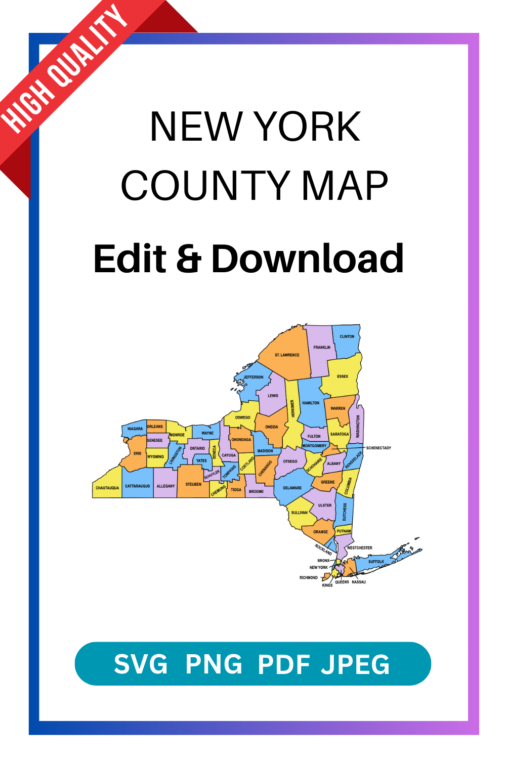
New York County Map: Editable & Printable State County Maps
Looking for accurate and customizable maps of New York? Our New York County Map collection provides high-quality, editable, and printable county maps of the state. Perfect for teachers, students, businesses, and researchers who need reliable geographical and county boundary information.
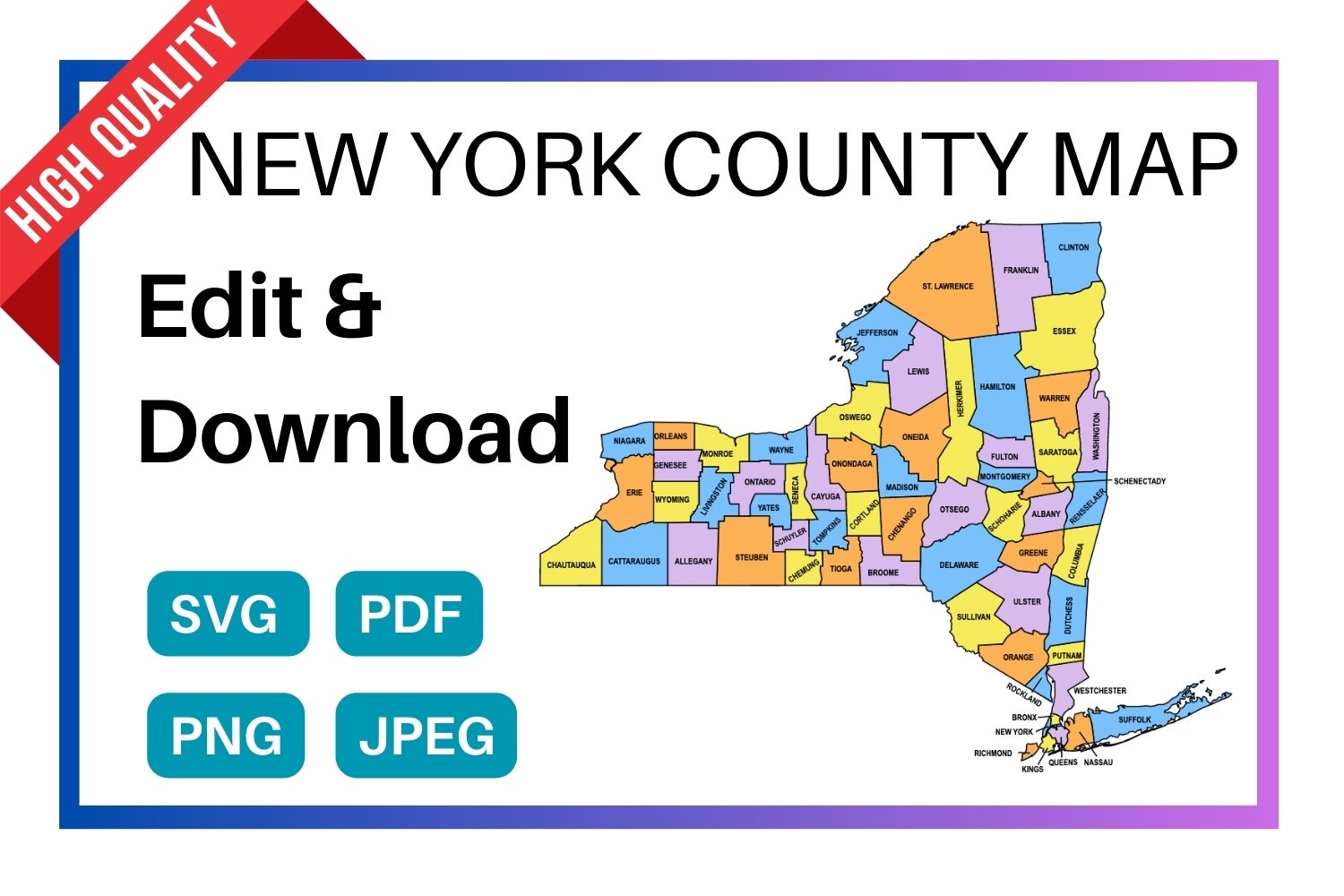
Download a free, editable New York county map in SVG, PDF, PNG or JPG. Perfect for classroom projects, presentations, geography research, and Cricut or Silhouette cutting machines.
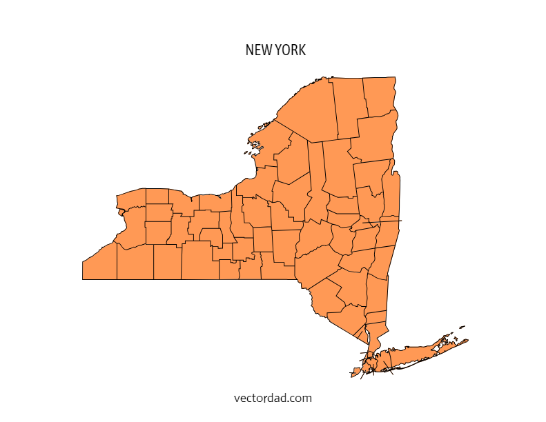
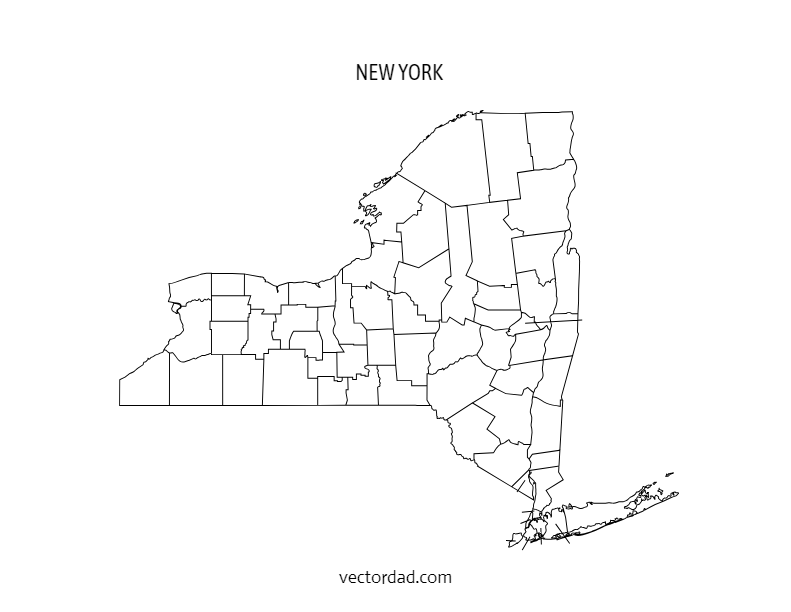
Types of New York County Maps
Choose from four styles of the New York county map — each available as a free editable download in SVG, PDF, PNG and JPG.
New York County Map — File Details
| Detail | Information |
|---|---|
| State | New York |
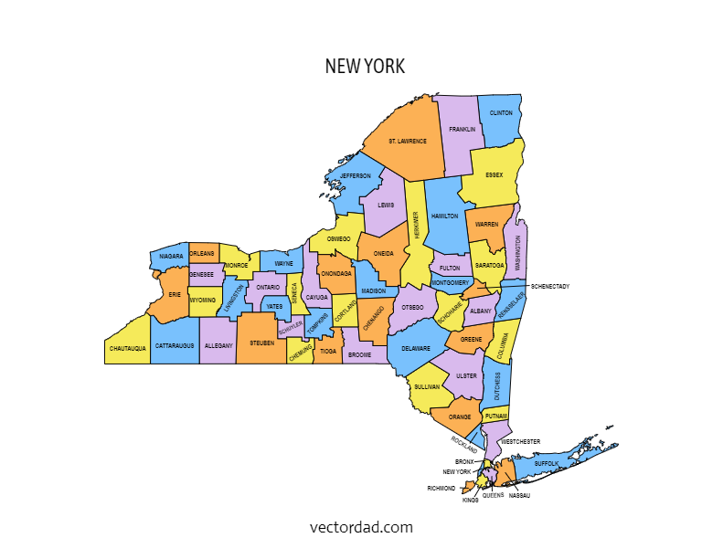
| Number of counties | 62 counties |
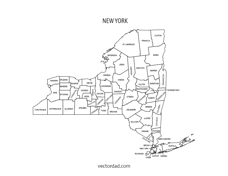
| Map type | Multi-colored county map (each county a distinct color) |
| File formats | SVG, PDF, PNG, JPG |
| Paper sizes | A4 and US Letter |
| Editable | Yes — customize text, colors, and elements in the online editor |
| Print ready | Yes — high resolution, suitable for home and professional printing |
| Cost | Free to download |
Download the SVG format — it cuts perfectly on all major cutting machines. Cricut Design Space and Silhouette Studio both import SVG files directly with no tracing needed.
Shop Cricut → Shop Silhouette →
What Can You Use This New York County Map For?
This free printable New York county map is used across a wide range of projects. Here are the most common uses:
| Use Case | Description |
|---|---|
| Education & classrooms | Teachers use county maps for geography lessons, quiz worksheets, and student reference handouts. |
| Research & data visualization | Researchers, analysts, and journalists overlay demographic, election, or economic data county by county. |
| Cricut & Silhouette projects | Crafters cut the SVG file to create vinyl maps, wood engravings, and personalised gifts. |
| Presentations & reports | Business and government presentations use county maps to illustrate regional coverage or service areas. |
| Travel & road trips | Travellers print county maps to plan routes and track visited counties in the state. |
| Real estate & planning | Agents and planners reference county boundaries when discussing territory, zoning, or coverage areas. |
| Wall art & home decor | Printed on A3 or larger, the colored county map makes a striking piece of wall art for New York natives. |
Why Choose Our New York County Maps?
✅ Editable Formats – Customize maps in PowerPoint, Illustrator, PDF, or image formats.
✅ Printable in High Resolution – Ideal for classroom use, business reports, or wall displays.
✅ Detailed County Boundaries – Covers all 62 counties of New York State.
✅ Multiple Versions – Labeled, blank (outline only), and colored maps available.
✅ Instant Download – Access your maps immediately after selection.
Who Can Use These Maps?
- Educators & Students – Teach and learn New York geography with blank or labeled maps.
- Businesses & Marketers – Highlight service areas, sales territories, or regional markets.
- Researchers & Planners – Visualize demographic, political, or economic data.
- Travel & Tourism Agencies – Showcase attractions by county for guides and brochures.
- DIY & Creatives – Use editable maps for projects, infographics, or wall art.
What’s Included?
- Labeled New York County Map – Counties clearly marked with names and boundaries.
- Blank/Outline County Map – Ideal for quizzes, coloring, or custom data visualization.
- Editable Digital Map Files – Modify colors, add text, or highlight areas.
- Printable PDFs & Images – Ready for high-quality printing at any size.
How to Use
- Choose Your Map Style – Labeled, blank, colored, or outline.
- Download Instantly – Get access in PDF, PNG, or editable file formats.
- Customize (Optional) – Edit in software like Illustrator, PowerPoint, or Photoshop.
- Print or Share – Use for education, business, or personal projects.
Get Your New York County Map Today
Our New York County Maps are designed for clarity, flexibility, and professional use. Whether you need them for teaching, planning, or presentation, these maps are your perfect resource.
The FREE editable and printable New York county map with seat cities. These printable maps are hard to find on Google. They come with all county labels (without county seats), are simple, and are easy to print. This New York county map is an essential resource for anyone seeking to explore and gather more information about the counties of the state.
SUGGEST US
We are constantly working on the enhancment by adding various new templates. If you experience any issues or you have any suggestions for us with this editor tool, feel free to contact us at vectordad24@gmail.com.
The templates includes New York multi colored county map, New York county map outline with labels, New York colored blank county map, and New York county outline map with border. Please share with us any templates that you would like us to add to the gallery.
New York county map, whether editable or printable, are valuable tools for understanding the geography and distribution of counties within the state. Printable maps with county names are popular among educators, researchers, travelers, and individuals who need a physical map for reference or display. They can be used in classrooms for teaching geography, in offices for planning and analysis, or as wall maps for decoration.With their customizable and printable features, The maps of New York counties provide flexibility and convenience for users to use maps with county area boundaries that meet their specific needs. Whether used for educational, professional, or personal purposes.
List of 62 New York counties with seat cities
- Albany County – Albany
- Allegany County – Belmont
- Bronx County – The Bronx
- Broome County – Binghamton
- Cattaraugus County – Little Valley
- Cayuga County – Auburn
- Chautauqua County – Mayville
- Chemung County – Elmira
- Chenango County – Norwich
- Clinton County – Plattsburgh
- Columbia County – Hudson
- Cortland County – Cortland
- Delaware County – Delhi
- Dutchess County – Poughkeepsie
- Erie County – Buffalo
- Essex County – Elizabethtown
- Franklin County – Malone
- Fulton County – Johnstown
- Genesee County – Batavia
- Greene County – Catskill
- Hamilton County – Lake Pleasant
- Herkimer County – Herkimer
- Jefferson County – Watertown
- Kings County – Brooklyn
- Lewis County – Lowville
- Livingston County – Geneseo
- Madison County – Wampsville
- Monroe County – Rochester
- Montgomery County – Fonda
- Nassau County – Mineola
- New York County – Manhattan
- Niagara County – Lockport
- Oneida County – Utica
- Onondaga County – Syracuse
- Ontario County – Canandaigua
- Orange County – Goshen
- Orleans County – Albion
- Oswego County – Oswego
- Otsego County – Cooperstown
- Putnam County – Carmel
- Queens County – Queens
- Rensselaer County – Troy
- Richmond County – Staten Island
- Rockland County – New City
- Saratoga County – Ballston Spa
- Schenectady County – Schenectady
- Schoharie County – Schoharie
- Schuyler County – Watkins Glen
- Seneca County – Waterloo
- St. Lawrence County – Canton
- Steuben County – Bath
- Suffolk County – Riverhead
- Sullivan County – Monticello
- Tioga County – Owego
- Tompkins County – Ithaca
- Ulster County – Kingston
- Warren County – Lake George
- Washington County – Fort Edward
- Wayne County – Lyons
- Westchester County – White Plains
- Wyoming County – Warsaw
- Yates County – Penn Yan
Pin it here
State County Maps (Printable State Maps with County Lines)
- Alabama
- Alaska
- Arizona
- Arkansas
- California
- Colorado
- Connecticut
- Delaware
- Florida
- Georgia
- Hawaii
- Idaho
- Illinois
- Indiana
- Iowa
- Kansas
- Kentucky
- Louisiana
- Maine
- Maryland
- Massachusetts
- Michigan
- Minnesota
- Mississippi
- Missouri
- Montana
- Nebraska
- Nevada
- New Hampshire
- New Jersey
- New Mexico
- New York
- North Carolina
- North Dakota
- Ohio
- Oklahoma
- Oregon
- Pennsylvania
- Rhode Island
- South Carolina
- South Dakota
- Tennessee
- Texas
- Utah
- Vermont
- Virginia
- Washington
- West Virginia
- Wisconsin
- Wyoming
Uses and Types of Materials
You can utilize these patterns, stencils, templates, models, and shapes for creating other unique objects or sublimation. With these designs you can create your own craft personalized, custom projects for your home, or even for selling online or at craft shows. These versatile designs are perfect for coloring pages and sheets, crochet patterns, drawing and painting, SVG files for Cricut and Silhouette machines, hobbies, holiday crafts, iron-on designs, kid crafts, laser cutting, needlecrafts, preschool printables, quilting, sewing, scrapbooking, sign making, string art (nail art), wall art, wedding crafts, woodworking projects, and other delightful DIY arts and crafts. Now create and make something truly special with these wonderful design resources!
These printable patterns can be easily transferred onto an array of materials, such as cardboard, cardstock, canvas, construction paper, fabric, felt, foam, glass, leather, metal, notebook paper, paper, parchment paper, photo paper, plastic, plexiglass, poster board, rubber, steel, vinyl, wax paper, wrapping paper, wood, and so many other types of materials. Experiment with different mediums and let your imagination soar as you create stunning projects that reflect your unique style and vision.
STEP BY STEP HELP TUTORIAL
It’s super easy and fun to edit and download county map in no time. Choose the shape templates, click the edit/download button and follow the steps below.
1. Change color:
Change the map color from the color picker (e.g., red, orange, yellow, green, blue, purple, pink, brown, gray or grey, black, white, beige, turquoise, gold, silver, lavender, indigo, magenta, maroon, olive, teal, navy, peach, cream, crimson, fuchsia, chartreuse, coral, khaki, mauve, rust, salmon, tan, violet, burgundy, chocolate, slate, taupe, eggplant, or forest green) to switch between different colors. The color change directly reflects the stage.
2. Enter the Pixel:
Next, enter the pixel size of the downloaded image to maximum upto 6000.
3. Download the final output:
Apply the above changes and download the final output as a high-quality PNG image or JPG image or PDF or vector SVG file format for your next great project.
Frequently Asked Questions
Is this New York county map really free?
Yes, completely free to download. Choose from SVG, PDF, PNG, or JPG formats. No account required.
Can I edit the colors and text on the map?
Yes. Click the “Customize & Download” button to open the online editor. You can change county colors, add text labels, adjust fonts, and reposition elements.
What size does the map print at?
The map is available in A4 and US Letter sizes. For larger format printing, use the SVG file — it scales to any size without losing quality.
Will this SVG file work with my Cricut?
Yes. The SVG file imports directly into Cricut Design Space. It also works with Silhouette Studio, Brother ScanNCut, and most other cutting machine software.
How many counties does New York have?
New York has 62 counties. All 62 are shown on the county map with labels version.
Can I use this map in a commercial project?
Please refer to the VectorDad terms of use page for commercial licensing details before using the map in paid or commercial work.