
- Other Counties
- ▸ Alabama
- ▸ Alaska
- ▸ Arizona
- ▸ Arkansas
- ▸ California
- ▸ Colorado
- ▸ Connecticut
- ▸ Delaware
- ▸ Florida
- ▸ Georgia
- ▸ Hawaii
- ▸ Idaho
- ▸ Illinois
- ▸ Indiana
- ▸ Iowa
- ▸ Kansas
- ▸ Kentucky
- ▸ Louisiana
- ▸ Maine
- ▸ Maryland
- ▸ Massachusetts
- ▸ Michigan
- ▸ Minnesota
- ▸ Mississippi
- ▸ Missouri
- ▸ Montana
- ▸ Nebraska
- ▸ Nevada
- ▸ New Hampshire
- ▸ New Jersey
- ▸ New Mexico
- ▸ New York
- ▸ North Carolina
- ▸ North Dakota
- ▸ Ohio
- ▸ Oklahoma
- ▸ Oregon
- ▸ Pennsylvania
- ▸ Rhode Island
- ▸ South Carolina
- ▸ South Dakota
- ▸ Tennessee
- ▸ Texas
- ▸ Utah
- ▸ Vermont
- ▸ Virginia
- ▸ Washington
- ▸ West Virginia
- ▸ Wisconsin
- ▸ Wyoming
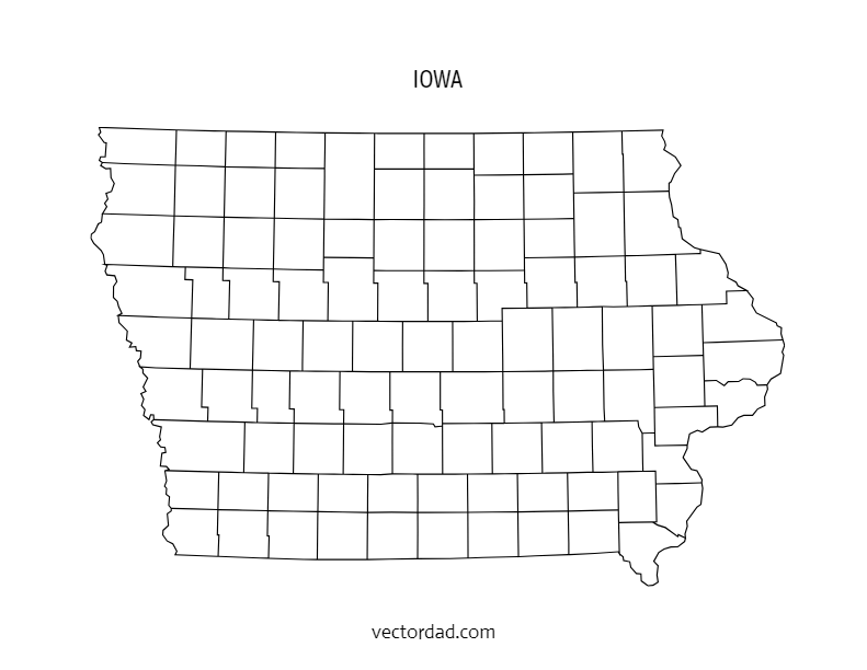
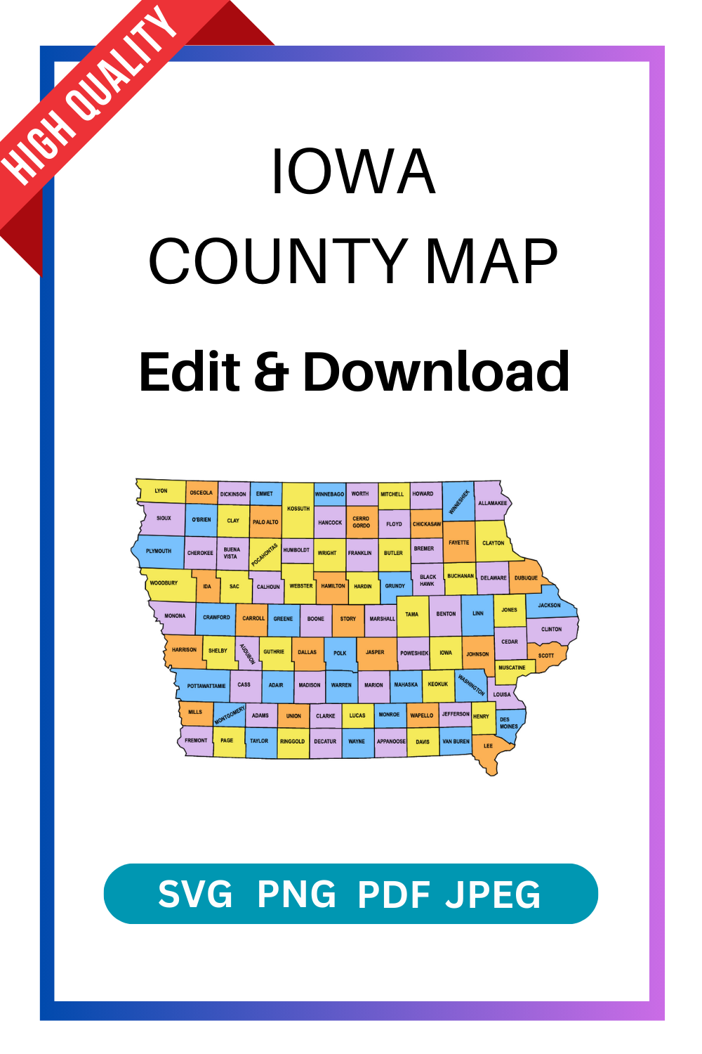
Iowa County Map: Editable & Printable State County Maps
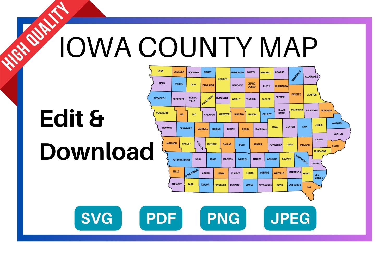
Download a free, editable Iowa county map in SVG, PDF, PNG or JPG. Perfect for classroom projects, presentations, geography research, and Cricut or Silhouette cutting machines.
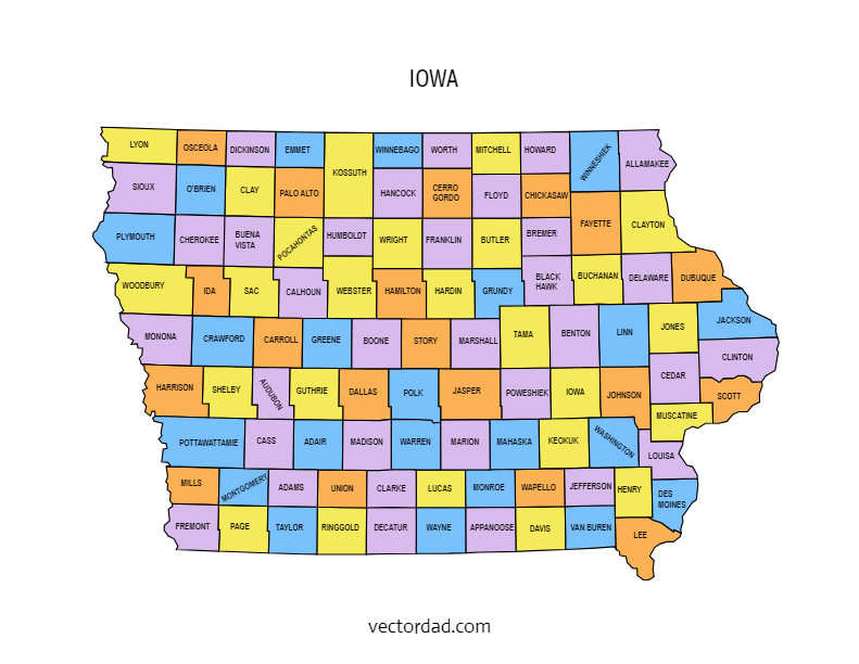
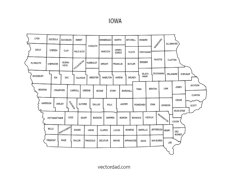
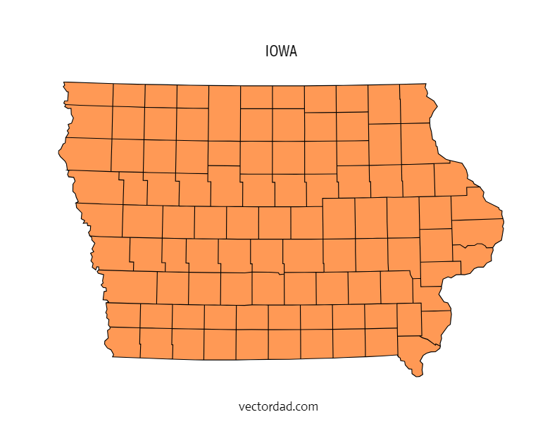
Types of Iowa County Maps
Choose from four styles of the Iowa county map — each available as a free editable download in SVG, PDF, PNG and JPG.
Iowa County Map — File Details
| Detail | Information |
|---|---|
| State | Iowa |
| Number of counties | 99 counties |
| Map type | Multi-colored county map (each county a distinct color) |
| File formats | SVG, PDF, PNG, JPG |
| Paper sizes | A4 and US Letter |
| Editable | Yes — customize text, colors, and elements in the online editor |
| Print ready | Yes — high resolution, suitable for home and professional printing |
| Cost | Free to download |
Download the SVG format — it cuts perfectly on all major cutting machines. Cricut Design Space and Silhouette Studio both import SVG files directly with no tracing needed.
Shop Cricut → Shop Silhouette →
What Can You Use This Iowa County Map For?
This free printable Iowa county map is used across a wide range of projects. Here are the most common uses:
| Use Case | Description |
|---|---|
| Education & classrooms | Teachers use county maps for geography lessons, quiz worksheets, and student reference handouts. |
| Research & data visualization | Researchers, analysts, and journalists overlay demographic, election, or economic data county by county. |
| Cricut & Silhouette projects | Crafters cut the SVG file to create vinyl maps, wood engravings, and personalised gifts. |
| Presentations & reports | Business and government presentations use county maps to illustrate regional coverage or service areas. |
| Travel & road trips | Travellers print county maps to plan routes and track visited counties in the state. |
| Real estate & planning | Agents and planners reference county boundaries when discussing territory, zoning, or coverage areas. |
| Wall art & home decor | Printed on A3 or larger, the colored county map makes a striking piece of wall art for Iowa natives. |
The FREE editable and printable Iowa county map with seat cities. These printable maps are hard to find on Google. They come with all county labels (without county seats), are simple, and are easy to print. This Iowa county map is an essential resource for anyone seeking to explore and gather more information about the counties of the state.
SUGGEST US
We are constantly working on the enhancment by adding various new templates. If you experience any issues or you have any suggestions for us with this editor tool, feel free to contact us at vectordad24@gmail.com.
The templates includes Iowa multi colored county map, Iowa county map outline with labels, Iowa colored blank county map, and Iowa county outline map with border. Please share with us any templates that you would like us to add to the gallery.
Iowa county map, whether editable or printable, are valuable tools for understanding the geography and distribution of counties within the state. Printable maps with county names are popular among educators, researchers, travelers, and individuals who need a physical map for reference or display. They can be used in classrooms for teaching geography, in offices for planning and analysis, or as wall maps for decoration.With their customizable and printable features, The maps of Iowa counties provide flexibility and convenience for users to use maps with county area boundaries that meet their specific needs. Whether used for educational, professional, or personal purposes.
List of 99 Iowa counties with seat cities
- Adair County – Greenfield
- Adams County – Corning
- Allamakee County – Waukon
- Appanoose County – Centerville
- Audubon County – Audubon
- Benton County – Vinton
- Black Hawk County – Waterloo
- Boone County – Boone
- Bremer County – Waverly
- Buchanan County – Independence
- Buena Vista County – Storm Lake
- Butler County – Allison
- Calhoun County – Rockwell City
- Carroll County – Carroll
- Cass County – Atlantic
- Cedar County – Tipton
- Cerro Gordo County – Mason City
- Cherokee County – Cherokee
- Chickasaw County – New Hampton
- Clarke County – Osceola
- Clay County – Spencer
- Clayton County – Elkader
- Clinton County – Clinton
- Crawford County – Denison
- Dallas County – Adel
- Davis County – Bloomfield
- Decatur County – Leon
- Delaware County – Manchester
- Des Moines County – Burlington
- Dickinson County – Spirit Lake
- Dubuque County – Dubuque
- Emmet County – Estherville
- Fayette County – West Union
- Floyd County – Charles City
- Franklin County – Hampton
- Fremont County – Sidney
- Greene County – Jefferson
- Grundy County – Grundy Center
- Guthrie County – Guthrie Center
- Hamilton County – Webster City
- Hancock County – Garner
- Hardin County – Eldora
- Harrison County – Logan
- Henry County – Mount Pleasant
- Howard County – Cresco
- Humboldt County – Dakota City
- Ida County – Ida Grove
- Iowa County – Marengo
- Jackson County – Maquoketa
- Jasper County – Newton
- Jefferson County – Fairfield
- Johnson County – Iowa City
- Jones County – Anamosa
- Keokuk County – Sigourney
- Kossuth County – Algona
- Lee County – Fort Madison
- Linn County – Cedar Rapids
- Louisa County – Wapello
- Lucas County – Chariton
- Lyon County – Rock Rapids
- Madison County – Winterset
- Mahaska County – Oskaloosa
- Marion County – Knoxville
- Marshall County – Marshalltown
- Mills County – Glenwood
- Mitchell County – Osage
- Monona County – Onawa
- Monroe County – Albia
- Montgomery County – Red Oak
- Muscatine County – Muscatine
- O’Brien County – Primghar
- Osceola County – Sibley
- Page County – Clarinda
- Palo Alto County – Emmetsburg
- Plymouth County – Le Mars
- Pocahontas County – Pocahontas
- Polk County – Des Moines
- Pottawattamie County – Council Bluffs
- Poweshiek County – Montezuma
- Ringgold County – Mount Ayr
- Sac County – Sac City
- Scott County – Davenport
- Shelby County – Harlan
- Sioux County – Orange City
- Story County – Nevada
- Tama County – Toledo
- Taylor County – Bedford
- Union County – Creston
- Van Buren County – Keosauqua
- Wapello County – Ottumwa
- Warren County – Indianola
- Washington County – Washington
- Wayne County – Corydon
- Webster County – Fort Dodge
- Winnebago County – Forest City
- Winneshiek County – Decorah
- Woodbury County – Sioux City
- Worth County – Northwood
- Wright County – Clarion
Pin it here
State County Maps (Printable State Maps with County Lines)
- Alabama
- Alaska
- Arizona
- Arkansas
- California
- Colorado
- Connecticut
- Delaware
- Florida
- Georgia
- Hawaii
- Idaho
- Illinois
- Indiana
- Iowa
- Kansas
- Kentucky
- Louisiana
- Maine
- Maryland
- Massachusetts
- Michigan
- Minnesota
- Mississippi
- Missouri
- Montana
- Nebraska
- Nevada
- New Hampshire
- New Jersey
- New Mexico
- New York
- North Carolina
- North Dakota
- Ohio
- Oklahoma
- Oregon
- Pennsylvania
- Rhode Island
- South Carolina
- South Dakota
- Tennessee
- Texas
- Utah
- Vermont
- Virginia
- Washington
- West Virginia
- Wisconsin
- Wyoming
Uses and Types of Materials
You can utilize these patterns, stencils, templates, models, and shapes for creating other unique objects or sublimation. With these designs you can create your own craft personalized, custom projects for your home, or even for selling online or at craft shows. These versatile designs are perfect for coloring pages and sheets, crochet patterns, drawing and painting, SVG files for Cricut and Silhouette machines, hobbies, holiday crafts, iron-on designs, kid crafts, laser cutting, needlecrafts, preschool printables, quilting, sewing, scrapbooking, sign making, string art (nail art), wall art, wedding crafts, woodworking projects, and other delightful DIY arts and crafts. Now create and make something truly special with these wonderful design resources!
These printable patterns can be easily transferred onto an array of materials, such as cardboard, cardstock, canvas, construction paper, fabric, felt, foam, glass, leather, metal, notebook paper, paper, parchment paper, photo paper, plastic, plexiglass, poster board, rubber, steel, vinyl, wax paper, wrapping paper, wood, and so many other types of materials. Experiment with different mediums and let your imagination soar as you create stunning projects that reflect your unique style and vision.
STEP BY STEP HELP TUTORIAL
It’s super easy and fun to edit and download county map in no time. Choose the shape templates, click the edit/download button and follow the steps below.
1. Change color:
Change the map color from the color picker (e.g., red, orange, yellow, green, blue, purple, pink, brown, gray or grey, black, white, beige, turquoise, gold, silver, lavender, indigo, magenta, maroon, olive, teal, navy, peach, cream, crimson, fuchsia, chartreuse, coral, khaki, mauve, rust, salmon, tan, violet, burgundy, chocolate, slate, taupe, eggplant, or forest green) to switch between different colors. The color change directly reflects the stage.
2. Enter the Pixel:
Next, enter the pixel size of the downloaded image to maximum upto 6000.
3. Download the final output:
Apply the above changes and download the final output as a high-quality PNG image or JPG image or PDF or vector SVG file format for your next great project.
Frequently Asked Questions
Is this Iowa county map really free?
Yes, completely free to download. Choose from SVG, PDF, PNG, or JPG formats. No account required.
Can I edit the colors and text on the map?
Yes. Click the “Customize & Download” button to open the online editor. You can change county colors, add text labels, adjust fonts, and reposition elements.
What size does the map print at?
The map is available in A4 and US Letter sizes. For larger format printing, use the SVG file — it scales to any size without losing quality.
Will this SVG file work with my Cricut?
Yes. The SVG file imports directly into Cricut Design Space. It also works with Silhouette Studio, Brother ScanNCut, and most other cutting machine software.
How many counties does Iowa have?
Iowa has 99 counties. All 99 are shown on the county map with labels version.
Can I use this map in a commercial project?
Please refer to the VectorDad terms of use page for commercial licensing details before using the map in paid or commercial work.