
- Other Counties
- ▸ Alabama
- ▸ Alaska
- ▸ Arizona
- ▸ Arkansas
- ▸ California
- ▸ Colorado
- ▸ Connecticut
- ▸ Delaware
- ▸ Florida
- ▸ Georgia
- ▸ Hawaii
- ▸ Idaho
- ▸ Illinois
- ▸ Indiana
- ▸ Iowa
- ▸ Kansas
- ▸ Kentucky
- ▸ Louisiana
- ▸ Maine
- ▸ Maryland
- ▸ Massachusetts
- ▸ Michigan
- ▸ Minnesota
- ▸ Mississippi
- ▸ Missouri
- ▸ Montana
- ▸ Nebraska
- ▸ Nevada
- ▸ New Hampshire
- ▸ New Jersey
- ▸ New Mexico
- ▸ New York
- ▸ North Carolina
- ▸ North Dakota
- ▸ Ohio
- ▸ Oklahoma
- ▸ Oregon
- ▸ Pennsylvania
- ▸ Rhode Island
- ▸ South Carolina
- ▸ South Dakota
- ▸ Tennessee
- ▸ Texas
- ▸ Utah
- ▸ Vermont
- ▸ Virginia
- ▸ Washington
- ▸ West Virginia
- ▸ Wisconsin
- ▸ Wyoming
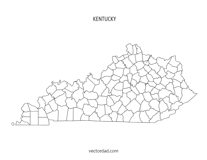
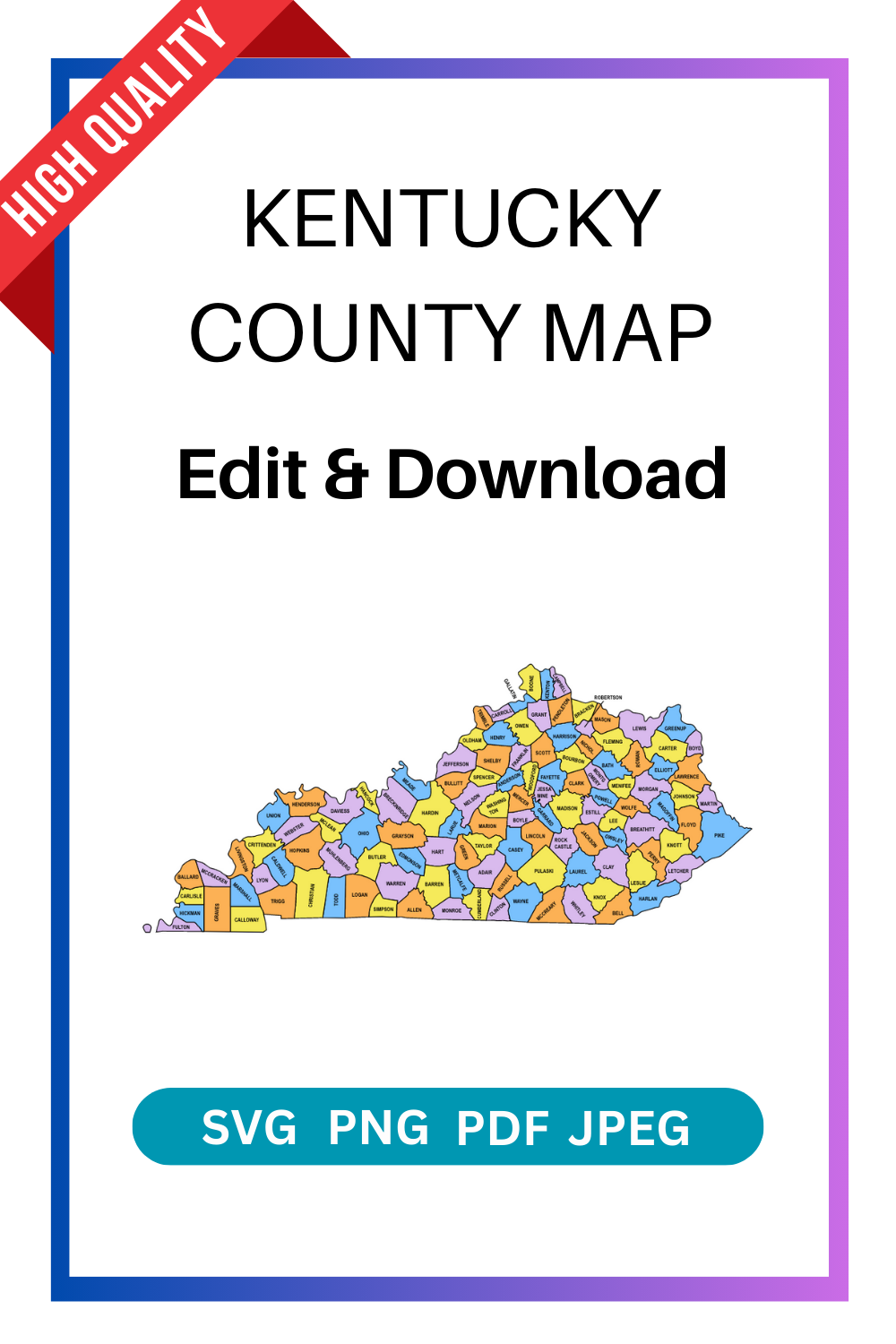
Kentucky County Map: Editable & Printable State County Maps
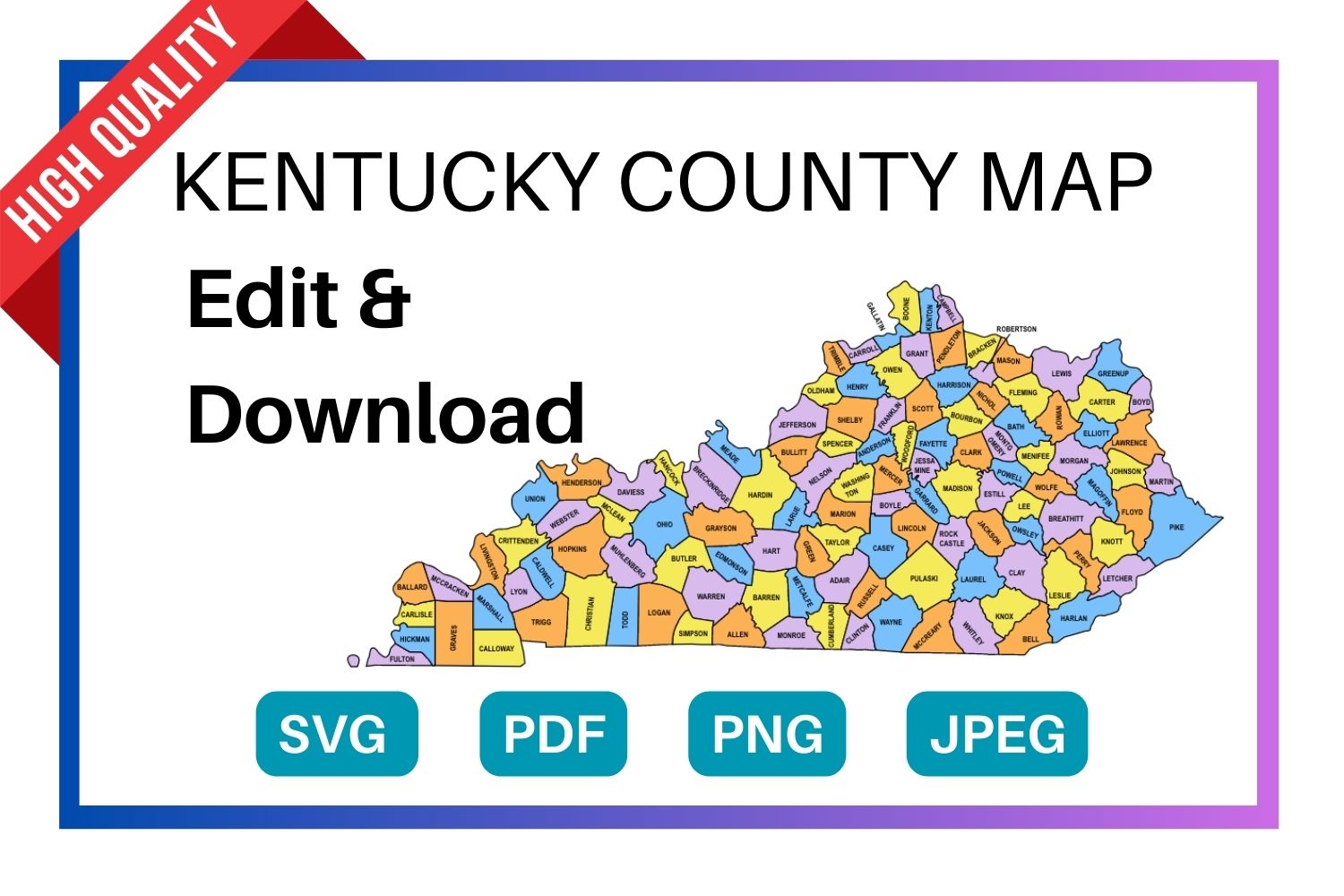
Download a free, editable Kentucky county map in SVG, PDF, PNG or JPG. Perfect for classroom projects, presentations, geography research, and Cricut or Silhouette cutting machines.
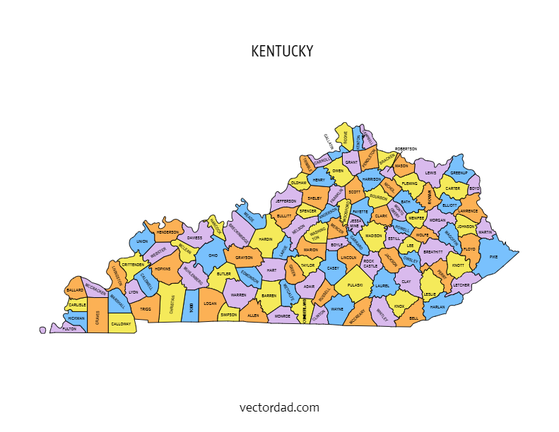
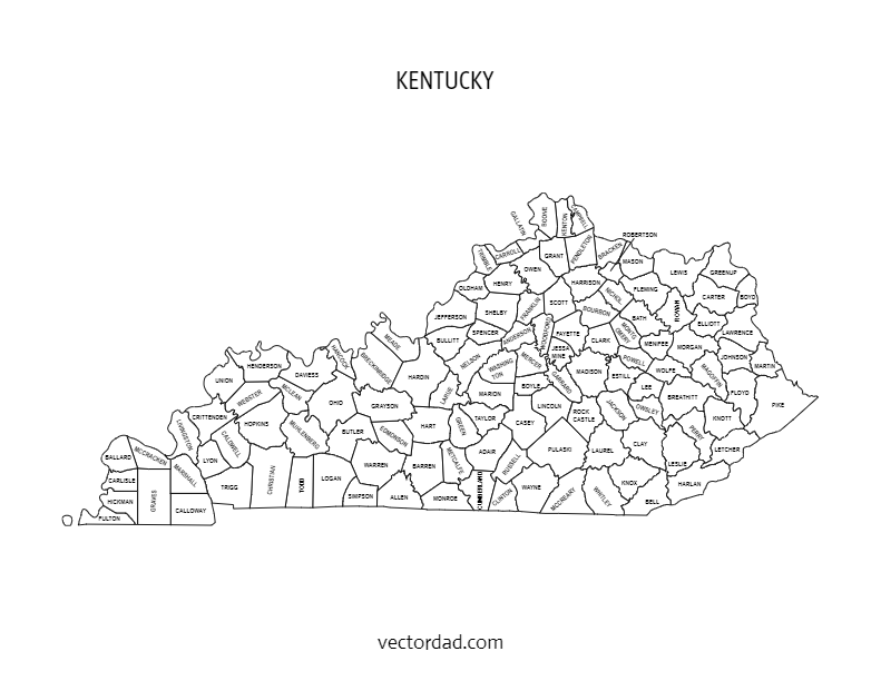
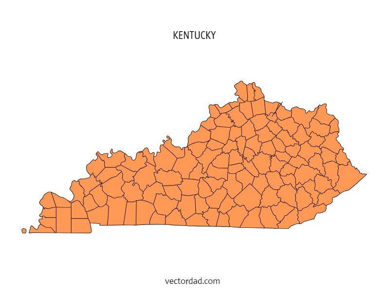
Types of Kentucky County Maps
Choose from four styles of the Kentucky county map — each available as a free editable download in SVG, PDF, PNG and JPG.
Kentucky County Map — File Details
| Detail | Information |
|---|---|
| State | Kentucky |
| Number of counties | 120 counties |
| Map type | Multi-colored county map (each county a distinct color) |
| File formats | SVG, PDF, PNG, JPG |
| Paper sizes | A4 and US Letter |
| Editable | Yes — customize text, colors, and elements in the online editor |
| Print ready | Yes — high resolution, suitable for home and professional printing |
| Cost | Free to download |
Download the SVG format — it cuts perfectly on all major cutting machines. Cricut Design Space and Silhouette Studio both import SVG files directly with no tracing needed.
Shop Cricut → Shop Silhouette →
What Can You Use This Kentucky County Map For?
This free printable Kentucky county map is used across a wide range of projects. Here are the most common uses:
| Use Case | Description |
|---|---|
| Education & classrooms | Teachers use county maps for geography lessons, quiz worksheets, and student reference handouts. |
| Research & data visualization | Researchers, analysts, and journalists overlay demographic, election, or economic data county by county. |
| Cricut & Silhouette projects | Crafters cut the SVG file to create vinyl maps, wood engravings, and personalised gifts. |
| Presentations & reports | Business and government presentations use county maps to illustrate regional coverage or service areas. |
| Travel & road trips | Travellers print county maps to plan routes and track visited counties in the state. |
| Real estate & planning | Agents and planners reference county boundaries when discussing territory, zoning, or coverage areas. |
| Wall art & home decor | Printed on A3 or larger, the colored county map makes a striking piece of wall art for Kentucky natives. |
Download Detailed, Editable & Printable Maps of Kentucky Counties
Need a clear and accurate map of Kentucky? Our Kentucky County Map collection provides high-quality, customizable, and printable maps featuring all 120 counties of Kentucky. Whether you need maps for classrooms, business planning, research, or creative projects, these county maps are the perfect resource.
Why Choose Our Kentucky County Maps?
✅ Editable Formats – Available in PDF, PowerPoint, Illustrator, and image files.
✅ High-Resolution & Printable – Suitable for reports, lessons, and wall charts.
✅ Detailed County Boundaries – Every county clearly outlined and labeled.
✅ Multiple Versions – Choose from labeled, blank (outline), or colored maps.
✅ Instant Download – Get access to your maps right away.
Who Can Use These Maps?
- Teachers & Students – Ideal for geography lessons, worksheets, and school projects.
- Businesses & Marketers – Highlight service areas, sales territories, or branch locations.
- Researchers & Analysts – Visualize demographic, political, or economic data.
- Government & Planners – Use for zoning, planning, and administrative reports.
- DIY Creatives & Hobbyists – Customize for crafts, infographics, or wall displays.
What’s Included?
- Labeled Kentucky County Map – All 120 counties clearly marked with names.
- Blank/Outline County Map – Perfect for coloring, quizzes, or data mapping.
- Editable Map Files – Customize colors, add highlights, or insert labels.
- Printable PDFs & Images – Ready-to-use for education, business, or presentations.
How to Use
- Pick a Map Style – Labeled, blank, or colored.
- Download Instantly – Get files in PDF, PNG, or editable formats.
- Edit (Optional) – Customize using PowerPoint, Illustrator, or Photoshop.
- Print & Use – Perfect for lessons, reports, or creative projects.
Get Your Kentucky County Map Today
Our Kentucky County Maps are accurate, professional, and versatile. Whether you’re a teacher, student, business owner, or researcher, these maps provide everything you need for clear visualization and presentation.
The FREE editable and printable Kentucky county map with seat cities. These printable maps are hard to find on Google. They come with all county labels (without county seats), are simple, and are easy to print. This Kentucky county map is an essential resource for anyone seeking to explore and gather more information about the counties of the state.
SUGGEST US
We are constantly working on the enhancment by adding various new templates. If you experience any issues or you have any suggestions for us with this editor tool, feel free to contact us at vectordad24@gmail.com.
The templates includes Kentucky multi colored county map, Kentucky county map outline with labels, Kentucky colored blank county map, and Kentucky county outline map with border. Please share with us any templates that you would like us to add to the gallery.
Kentucky county map, whether editable or printable, are valuable tools for understanding the geography and distribution of counties within the state. Printable maps with county names are popular among educators, researchers, travelers, and individuals who need a physical map for reference or display. They can be used in classrooms for teaching geography, in offices for planning and analysis, or as wall maps for decoration.With their customizable and printable features, The maps of Kentucky counties provide flexibility and convenience for users to use maps with county area boundaries that meet their specific needs. Whether used for educational, professional, or personal purposes.
List of 120 Kentucky counties with seat cities
- Adair County – Columbia
- Allen County – Scottsville
- Anderson County – Lawrenceburg
- Ballard County – Wickliffe
- Barren County – Glasgow
- Bath County – Owingsville
- Bell County – Pineville
- Boone County – Burlington
- Bourbon County – Paris
- Boyd County – Catlettsburg
- Boyle County – Danville
- Bracken County – Brooksville
- Breathitt County – Jackson
- Breckinridge County – Hardinsburg
- Bullitt County – Shepherdsville
- Butler County – Morgantown
- Caldwell County – Princeton
- Calloway County – Murray
- Campbell County – Newport
- Carlisle County – Bardwell
- Carroll County – Carrollton
- Carter County – Grayson
- Casey County – Liberty
- Christian County – Hopkinsville
- Clark County – Winchester
- Clay County – Manchester
- Clinton County – Albany
- Crittenden County – Marion
- Cumberland County – Burkesville
- Daviess County – Owensboro
- Edmonson County – Brownsville
- Elliott County – Sandy Hook
- Estill County – Irvine
- Fayette County – Lexington
- Fleming County – Flemingsburg
- Floyd County – Prestonsburg
- Franklin County – Frankfort
- Fulton County – Hickman
- Gallatin County – Warsaw
- Garrard County – Lancaster
- Grant County – Williamstown
- Graves County – Mayfield
- Grayson County – Leitchfield
- Green County – Greensburg
- Greenup County – Greenup
- Hancock County – Hawesville
- Hardin County – Elizabethtown
- Harlan County – Harlan
- Harrison County – Cynthiana
- Hart County – Munfordville
- Henderson County – Henderson
- Henry County – New Castle
- Hickman County – Clinton
- Hopkins County – Madisonville
- Jackson County – McKee
- Jefferson County – Louisville
- Jessamine County – Nicholasville
- Johnson County – Paintsville
- Kenton County – Covington
- Knott County – Hindman
- Knox County – Barbourville
- LaRue County – Hodgenville
- Laurel County – London
- Lawrence County – Louisa
- Lee County – Beattyville
- Leslie County – Hyden
- Letcher County – Whitesburg
- Lewis County – Vanceburg
- Lincoln County – Stanford
- Livingston County – Smithland
- Logan County – Russellville
- Lyon County – Eddyville
- Madison County – Richmond
- Magoffin County – Salyersville
- Marion County – Lebanon
- Marshall County – Benton
- Martin County – Inez
- Mason County – Maysville
- McCracken County – Paducah
- McCreary County – Whitley City
- McLean County – Calhoun
- Meade County – Brandenburg
- Menifee County – Frenchburg
- Mercer County – Harrodsburg
- Metcalfe County – Edmonton
- Monroe County – Tompkinsville
- Montgomery County – Mt. Sterling
- Morgan County – West Liberty
- Muhlenberg County – Greenville
- Nelson County – Bardstown
- Nicholas County – Carlisle
- Ohio County – Hartford
- Oldham County – La Grange
- Owen County – Owenton
- Owsley County – Booneville
- Pendleton County – Falmouth
- Perry County – Hazard
- Pike County – Pikeville
- Powell County – Stanton
- Pulaski County – Somerset
- Robertson County – Mt. Olivet
- Rockcastle County – Mt. Vernon
- Rowan County – Morehead
- Russell County – Jamestown
- Scott County – Georgetown
- Shelby County – Shelbyville
- Simpson County – Franklin
- Spencer County – Taylorsville
- Taylor County – Campbellsville
- Todd County – Elkton
- Trigg County – Cadiz
- Trimble County – Bedford
- Union County – Morganfield
- Warren County – Bowling Green
- Washington County – Springfield
- Wayne County – Monticello
- Webster County – Dixon
- Whitley County – Williamsburg
- Wolfe County – Campton
- Woodford County – Versailles
Pin it here
State County Maps (Printable State Maps with County Lines)
- Alabama
- Alaska
- Arizona
- Arkansas
- California
- Colorado
- Connecticut
- Delaware
- Florida
- Georgia
- Hawaii
- Idaho
- Illinois
- Indiana
- Iowa
- Kansas
- Kentucky
- Louisiana
- Maine
- Maryland
- Massachusetts
- Michigan
- Minnesota
- Mississippi
- Missouri
- Montana
- Nebraska
- Nevada
- New Hampshire
- New Jersey
- New Mexico
- New York
- North Carolina
- North Dakota
- Ohio
- Oklahoma
- Oregon
- Pennsylvania
- Rhode Island
- South Carolina
- South Dakota
- Tennessee
- Texas
- Utah
- Vermont
- Virginia
- Washington
- West Virginia
- Wisconsin
- Wyoming
Uses and Types of Materials
You can utilize these patterns, stencils, templates, models, and shapes for creating other unique objects or sublimation. With these designs you can create your own craft personalized, custom projects for your home, or even for selling online or at craft shows. These versatile designs are perfect for coloring pages and sheets, crochet patterns, drawing and painting, SVG files for Cricut and Silhouette machines, hobbies, holiday crafts, iron-on designs, kid crafts, laser cutting, needlecrafts, preschool printables, quilting, sewing, scrapbooking, sign making, string art (nail art), wall art, wedding crafts, woodworking projects, and other delightful DIY arts and crafts. Now create and make something truly special with these wonderful design resources!
These printable patterns can be easily transferred onto an array of materials, such as cardboard, cardstock, canvas, construction paper, fabric, felt, foam, glass, leather, metal, notebook paper, paper, parchment paper, photo paper, plastic, plexiglass, poster board, rubber, steel, vinyl, wax paper, wrapping paper, wood, and so many other types of materials. Experiment with different mediums and let your imagination soar as you create stunning projects that reflect your unique style and vision.
STEP BY STEP HELP TUTORIAL
It’s super easy and fun to edit and download county map in no time. Choose the shape templates, click the edit/download button and follow the steps below.
1. Change color:
Change the map color from the color picker (e.g., red, orange, yellow, green, blue, purple, pink, brown, gray or grey, black, white, beige, turquoise, gold, silver, lavender, indigo, magenta, maroon, olive, teal, navy, peach, cream, crimson, fuchsia, chartreuse, coral, khaki, mauve, rust, salmon, tan, violet, burgundy, chocolate, slate, taupe, eggplant, or forest green) to switch between different colors. The color change directly reflects the stage.
2. Enter the Pixel:
Next, enter the pixel size of the downloaded image to maximum upto 6000.
3. Download the final output:
Apply the above changes and download the final output as a high-quality PNG image or JPG image or PDF or vector SVG file format for your next great project.
Frequently Asked Questions
Is this Kentucky county map really free?
Yes, completely free to download. Choose from SVG, PDF, PNG, or JPG formats. No account required.
Can I edit the colors and text on the map?
Yes. Click the “Customize & Download” button to open the online editor. You can change county colors, add text labels, adjust fonts, and reposition elements.
What size does the map print at?
The map is available in A4 and US Letter sizes. For larger format printing, use the SVG file — it scales to any size without losing quality.
Will this SVG file work with my Cricut?
Yes. The SVG file imports directly into Cricut Design Space. It also works with Silhouette Studio, Brother ScanNCut, and most other cutting machine software.
How many counties does Kentucky have?
Kentucky has 120 counties. All 120 are shown on the county map with labels version.
Can I use this map in a commercial project?
Please refer to the VectorDad terms of use page for commercial licensing details before using the map in paid or commercial work.